Technology Profile
| Title: | Earthquake Risk Assessment of Lucknow and Dehradun: Risk Profiling through Buildings |
| Value Proposition: | Lucknow is the capital city of Uttar Pradesh with the largest population (~36 Lakhs) in the state. The city stands at 123 m above sea level and on the flat alluvial terrain of the Ganga river basin with the Gomti river flowing through. This area lies in Seismic Zone III, where moderate earthquake ground shaking is expected. It is one of the oldest cities with many monuments and historical and modern constructions. Similarly, Dehradun is the capital city of Uttarakhand with a population of ~9 Lakhs. The city stands is confined between the Main Boundary Thrust and Himalayan Frontal Thrust, the two prominent faults in the Himalayan mountain range. This area lies in Seismic Zone IV, where severe earthquake ground shaking is expected. It is one of the oldest cities with many monuments and historical and modern constructions. The city has mixed building typologies of houses made with unreinforced brick masonry, which is the most vulnerable typology, and new reinforced concrete buildings. Most buildings are constructed based on older design standards. This necessitates the earthquake assessment of buildings though the seismic hazard moderate and above moderate conditions. |
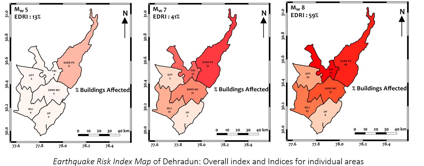
| Summary Application: | The CSIR National Geophysical Research Institute (NGRI) has proposed a first cut Earthquake Disaster Risk Index (EDRI) to capture relative risk across the city of Lucknow, using (Level 2 Method of Risk Assessment). It involves three components, namely Hazard, Vulnerability and Exposure. To estimate the Earthquake Hazard, earthquake measuring instruments were placed at 6 locations across the city (chosen based on population density), namely: Central Ground Water Board (CGWB), Indira Gandhi Institute of Cooperative Management (IGICM), National Botanical Research Institute (NBRI), Central Institute of Medical and Aromatic Plants (CIMAP), Delhi Public School (DPS) and Amity University (AMITY). To estimate the Earthquake Vulnerability, about 1,300 buildings were surveyed to understand their vulnerability through a Level 2 Vulnerability Assessment Study. And, the Earthquake Exposure is taken from the population data. Similarly, studies were undertaken for Dehradun also. To estimate the Earthquake Hazard, an earthquake measuring instruments were placed at 6 locations across the city (chosen based on population density), namely: Indian Institute of Petroleum, Mohkampur (IIP), Sri Guru Ram Rai Medical College in Patel Nagar (PTNR), Wildlife Institute of India in Chandrabani (WLI), Government Girls Polytechnic in Sudhowala (SUDH), Forest Research Institute in Ballupur (FRI) and Sri Guru Ram Rai Public School in Kandoli (KAND). To estimate the Earthquake Vulnerability, about 1,200 buildings were surveyed to understand their vulnerability through a Level 2 Vulnerability Assessment Study. And, the Earthquake Exposure is taken from the population data. The Salient Findings of the study are:
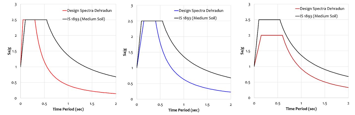
(1) Earthquake Hazard The shape of the Normalized Design Acceleration Spectrum for Lucknow City is different from that prescribed in the Indian Standard Code IS1893 (Part 1): 2016. Design Spectra are proposed for three expected events of Magnitudes 5, 7, and 8. Buildings in the range of 2-7 stories are expected to be worst affected. Also, flexible structures (Water Tanks, Taller Buildings, and other such Critical and Lifeline Structures) will be affected.
(2) Earthquake Vulnerability The following should be adopted in new masonry and reinforced concrete constructions: (a) Area of window and door openings should be small, and away from the corners. (b) Staircases should be located symmetrically in the plan. (c) Irregular geometries should be avoided in the plan and elevation of the buildings (d) Sizes of rooms should be small. (e) Horizontal bands should be provided in masonry buildings.
(3) Earthquake Disaster Risk Index (EDRI) On average, 59% of houses in Dehradun are expected to be affected by different grades of damage. But, in the FRI zone this value is as high as 78%. The broad field of specialization: Earthquake Hazard Assessment and Societal Benefit. The fields given in the Industrial application are not suiting for this study, hence mentioned only Monitoring which is also not a correct field.
|
| Advantages: | 1. These studies throw light on the vulnerability of highly important cultural and heritage sites in both cities. 2. The studies undertaken were very competent enough to make parameters based predictions on the response to seismogenesis
|
| Tech. Readiness Level: |